
MAPPING PLACES WORKING
I would like to pay my respect and acknowledge the Traditional owners of the land, the Gadigal people, the Gweagal people & the Bidjigal people of the Eora Nation, in which I studied, researched, and mapped. It is upon their ancestral land that I share knowledge in this module, such that I would like to pay respect to the knowledge embedded forever in the Aboriginal custodianship of Country.
EXPERIMENTATION WITH MATERIAL & TEXTURES

Materials I worked with:
- Waterproof Indian Ink
- Fountain Pen ink
- Technical Pen- 0.1
Techniques that I worked with:
- Bleeding through water
- Bleeding through Bamboo Pen
- Bleeding through brush
Thoughts:
I love the use of the bleeding technique with the ink as it creates watery-like patterns, which looks interesting and the contour type lines that it produces could show the flow of water.
SCALE #1: MAPPING AT TERRITORIAL SCALES
Experimenting through combining mapping and techniques
Chosen Layer 1: Wet to Dry
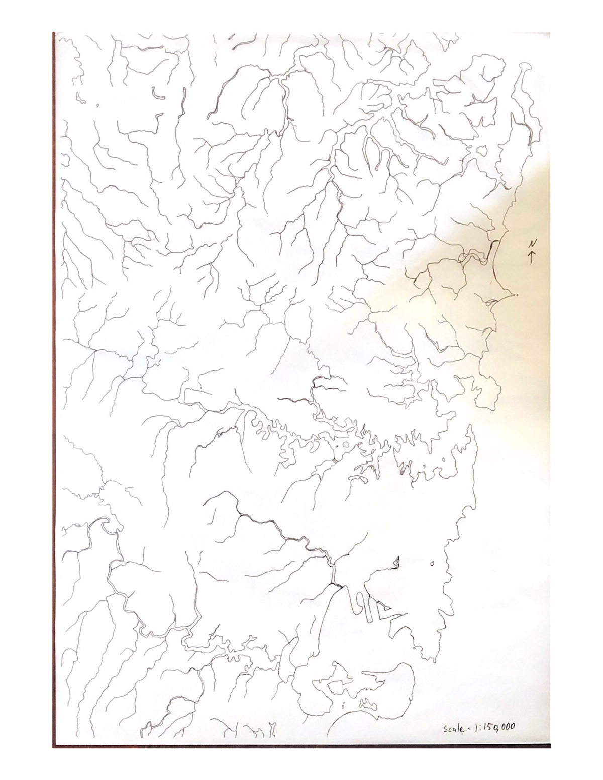
Technical Pen (combination of 0.1 & 0.2)
Traced the outline of every waterway
Thoughts:
Overall, it looks a bit too plain and simple despite the process taking a long time to produce. If combined with lead graphite or light charcoal, it can help show the wetness to dryness of the waterways.

Hatching (technical pen 0.4)
Line hatching
Thoughts:
Overall, I don't think the hatching will work as it is rather messy and it doesn't display the wateriness effect that I am looking for.


Bleeding technique:
1. For the larger parts of the waterway, I first brushed it with water using a paintbrush, then apply the ink by dabbing on the edge of the waterways using a smaller paintbrush. The smaller waterways are made using ink with a very thin paintbrush. Darker= more depth of wetness
2. For the larger parts of the waterway, I first applied the ink onto the outline using a paintbrush, then brush the ink outwards with water using a small paintbrush The smaller waterways are made using ink with a very thin paintbrush. Darker= more depth of wetness
Thoughts:
The bleeding technique works quite well in both the process of producing it and it gives a good depiction of the wetness to dryness. The first bleeding technique didn't bleed as much as I expected it would. The second bleeding technique worked very well as the fountain pen ink was initially black, but as it bleeds, the colours separate, giving the dark bluish colour, which is a very nice colour. However, the second bleeding technique, similar to the first bleeding technique, did not bleed as far as I thought it would.

Gradient Technique
First, I outlined the larger waterways with ink using a paintbrush, then try and create a 'gradient' effect using a paintbrush with ink that is diluted with water. With the smaller waterways, I used diluted ink to show the wetness and dryness.
Thoughts:
I kind of like how the 'gradient' effect represents the wetness to dryness very well, however I think the representation of the smaller waterways do not show the wetness to dryness very well.
Developing Bleeding Technique via Ink
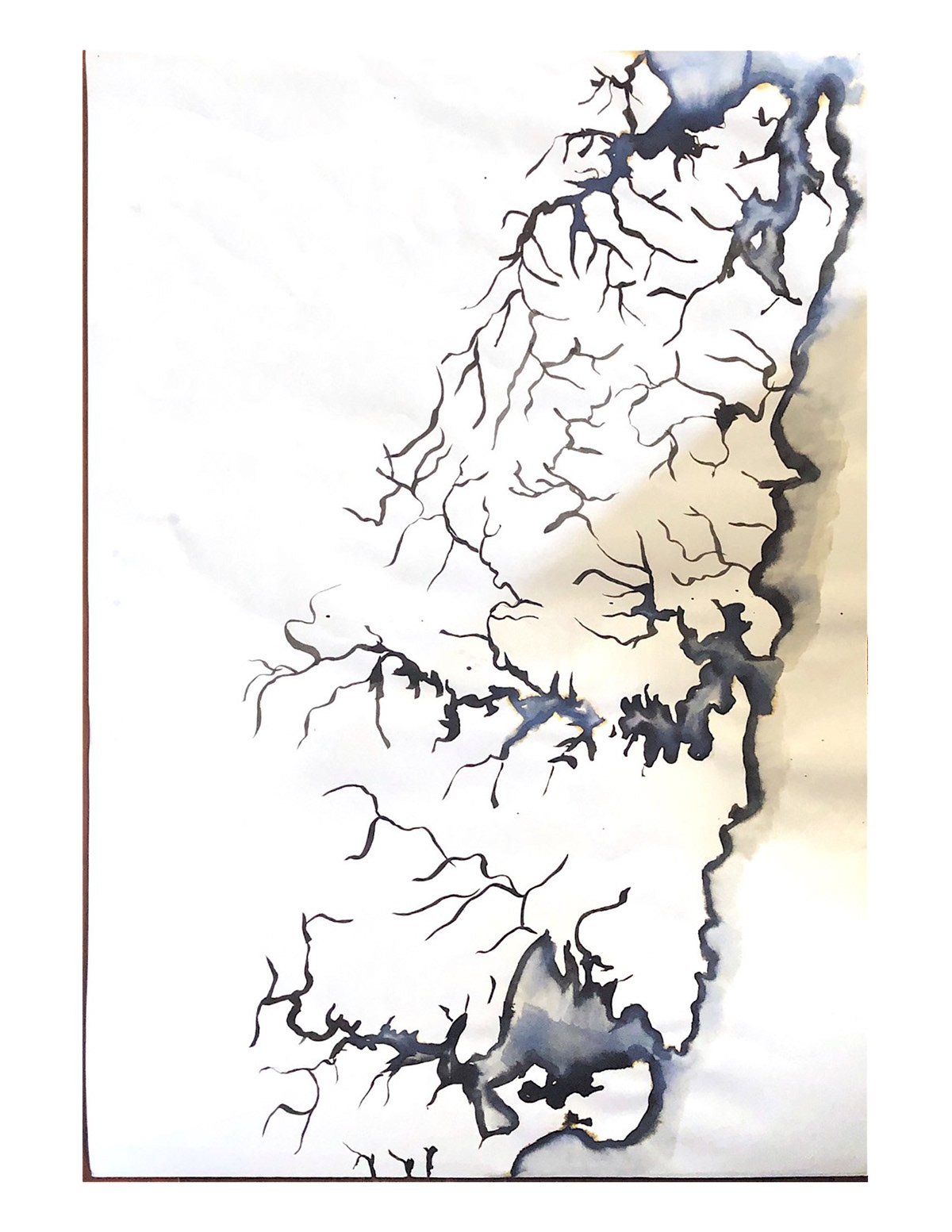
Instead of using a paintbrush to use ink to outline the waterway, I'm using a small calligraphy brush to improve more accuracy and for an easier control with the strokes for the smaller waterways.

I've thought of experimented with the ink to water ratio to try and 'extend' the bleeding to the edge of the page. I tried more water this time, and the bleeding did bleed further, but it is not enough.

I used more ink and a bit less water to try and extend the bleeding effect, which worked, however the bleeding effect needs to be 'extended'.
Finalised/Refined of Larger Scale (1:150,000)


Final iterations of 1:150,000 scale map
Final chosen 1:150,000 scale map

Thoughts:
By using more ink than the previous iterations, the ink was able to 'bleed' more out of the page. I was able to add more waterways for a more detailed map.
SCALE #2: MAPPING AT SINGULAR RIVER SCALE
Developing
Chosen Singular River: Mill Stream


First 1:2,000 iterations
1. I used the bleeding technique only on the light parts of the stream
2. I outlined every waterway of the stream using the bleeding technique
3. I used the bleeding technique on the third iteration and used different amount of ink depending on the 'wetness' levels
Thoughts:
I felt like the iterations were missing the wetness and dryness concept. On another note, I cannot access this part of the stream due to property.

Iteration of 1:4,000 of Mill Stream
Final & Chosen 1:2,000 scale map


I decided to go back to the 1:2,000 scale as I thought it would be appropriate to focus on one specific part of the stream rather than a fraction of it. Furthermore, By looking at my precedent, Irene Kopelman, utilise her technique of watercolour to create 'depth' and 'layers', I decided to use the bleeding technique not only inside the stream, but also slightly outside the stream to create 'depth' and 'wetness' to the watery base.
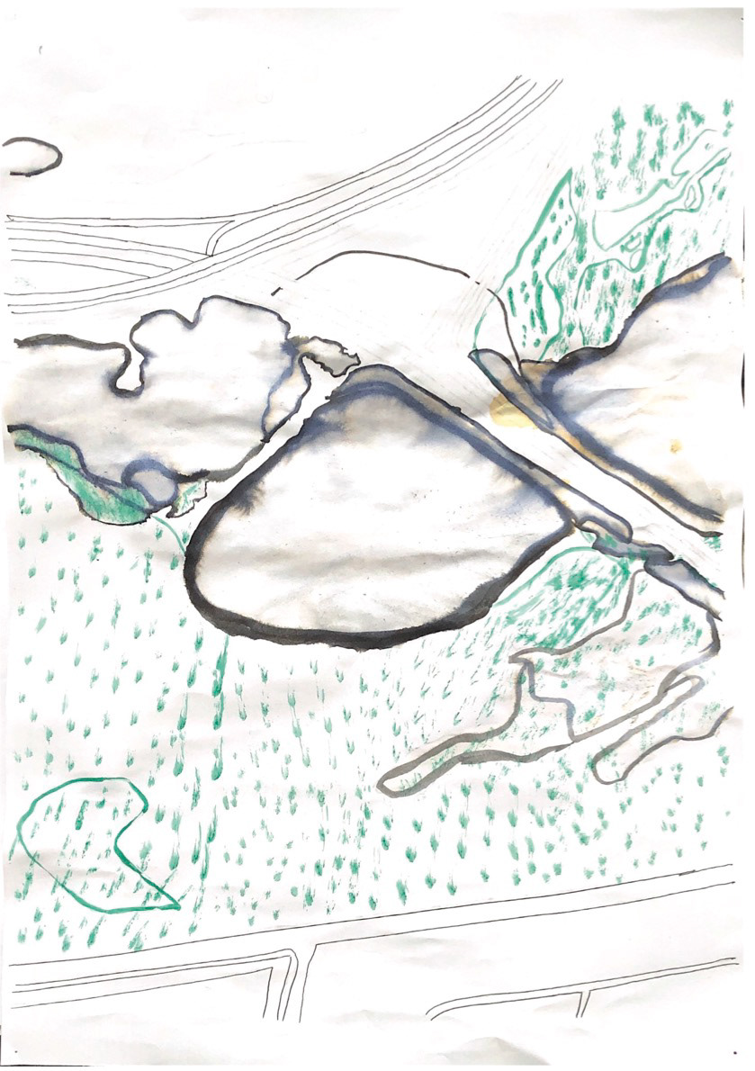
ADDING LAYERS
Chosen Layers:
Layer 1: WET TO DRY in Ink
The wetness of the ocean including depth. It is wetter in the depth of the ocean than in shallower areas as there is a greater volume of water
Layer 2: Vegetation
The vegetation surrounding the creek and parklands in the area including swamps, wetlands, parkland grasses, natural revegetation etc.
Layer 3: Roads
In the Territorial scale, we are only mapping out the highways. In the singular river scale, we are mapping out all roads.


Vegetation Iteration (Territorial)
1. I used a sharpie to outline vegetation
2. I used drawing ink and attempted the bleeding technique on the drawing in to create 'depth' and lighter vegetations

Original 1:2,000 scale layering before deciding on changing the scale to 1:4,000
New 1:2,000 scale layering after deciding on changing the scale fro, 1:4,000 back to 1:2,000
Thoughts:
Overall, I feel like the vegetation iterations 'overpower' the watery base, making the water to not stand out as much at it should, so I decided to create the road and vegetation layers digitally. Moreover, I decided to diverge the vegetation layer into 3 main vegetations: Wet vegetation, Dry vegetation, and Wetland.

Attempt on the 1:4,000 scale with the chosen layers before I talked to Rosalie and decided to change back to 1:2,000

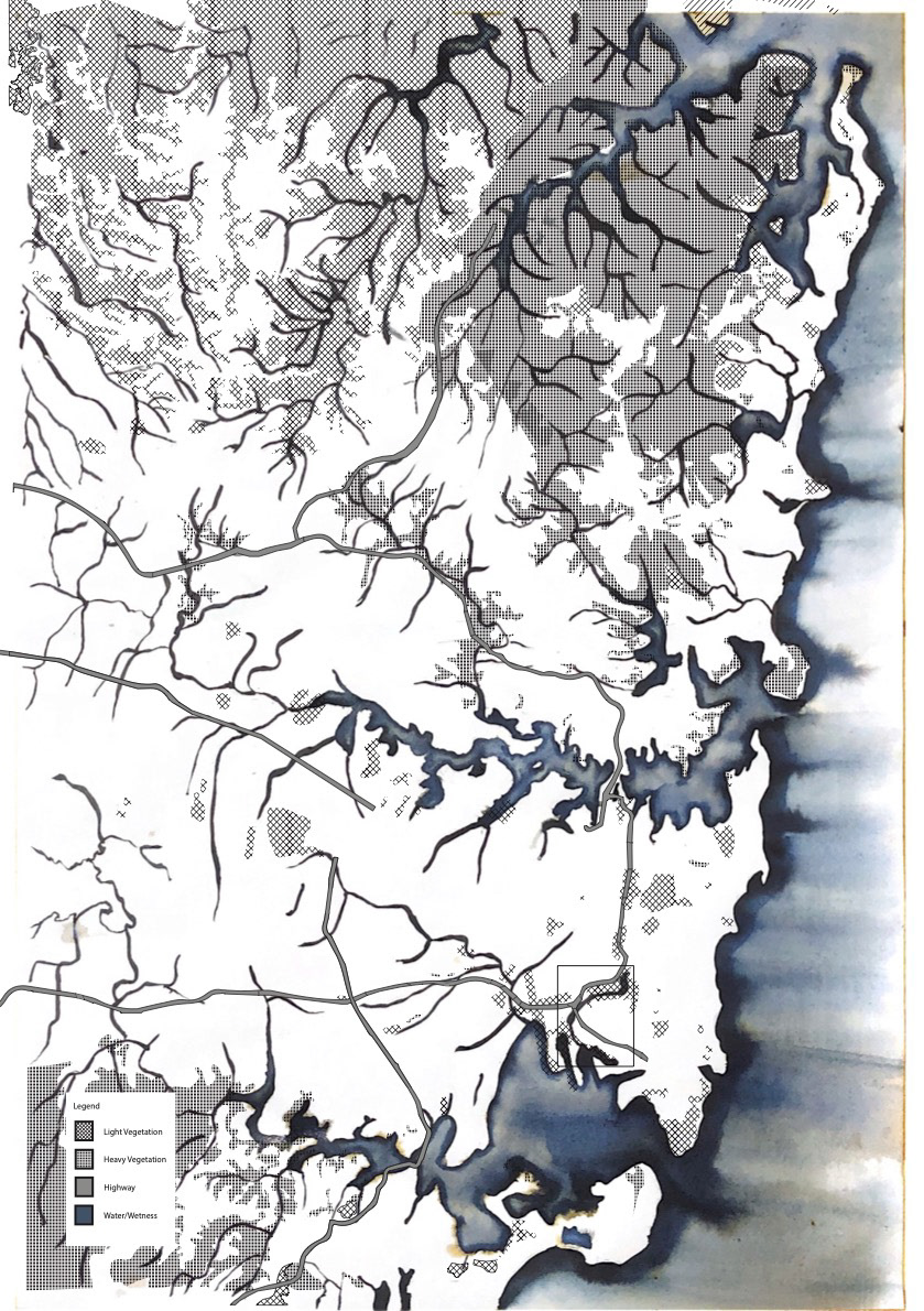
With the singular river scale after talking with Rosalie about it, I decided to remove the tree layer and the sand layer in order to for the map to focus more on the coexistence between the vegetation and the roads (the natural and synthetic relationship). Moreover, I decided to stray the territorial scale towards what the singular river scale was doing in terms of what I'm layering in the vegetation.
SCALE #3: PERSONAL SCALE
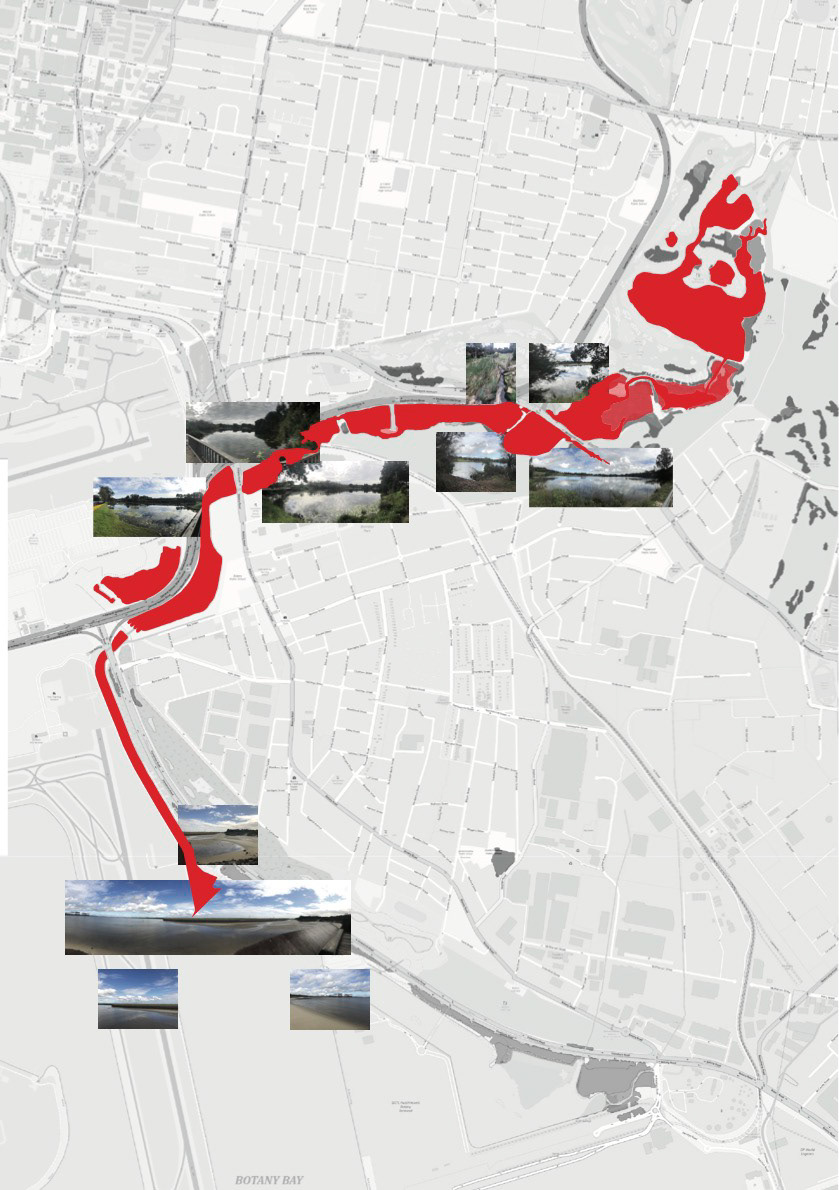
Visit 1
I decided to go to this location specifically for now as I was mapping out this area.

Visit 1 photographs


I discovered on my first trip that some areas were restricted due to the stream being close to the golf club and being restricted in terms of how close we can get, meaning that I was unable to go to the creeks edge and access some parts of the stream.
Visit 2
I decided to take a look at the rest of the stream as I was curious if:
1. I was able to access the other parts of the stream that i thought I didn't have access to
2. To investigate the relationship between the vegetation and the roads on the other sectors of the stream.

Visit 2 Photographs


I discovered that some parts of the stream was not accessible due to private property, but I was able to access a few more areas of the stream and understand a bit more with the relationship between both the natural and synthetic structures, and noticed that there are similar vegetation despite the stream going from saltwater to freshwater.
Iteration 1 of the personal scale
Thoughts:
Overall, I feel like that the greyscale background and the unedited photos don't go too well, and that using the whole stream on the personal scale didn't feel 'personal'.

Iteration 2 of the personal scale
Thoughts:
Personally, I like the use of the 1:2,000 scale stream as the background, but I feel like that turning down the opacity of the photographs and saturating the colours towards the colour blue would help bring out the relationship of the photographs with the stream on the background.
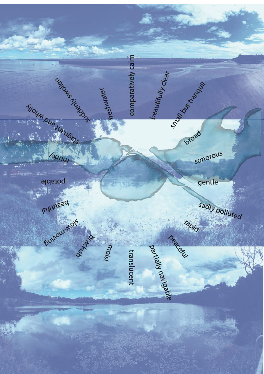
Edited Chosen Photos
I decided to make the photographs saturated more into the colour blue to tie in with my bluish watery base of my smaller scale map and to connect with the actual colour of the creek. This allowed me to focus more on the water and vegetation that I photographed.

ACT OF CARE
For the act of care, I decided to write a sensory poem of my thoughts and feelings about the stream when I went there.
Act of care iteration 1
Thoughts:
After talking with Rosalie about the background behind the poem, I decided to remove the background as I thought that the background drove away the focus of the poem.

Act of care iteration 2
Thoughts:
I felt like the shape of the poem didn't make the significant enough and I wanted it to fit into my definition of what mapping is, so I decided to have the words stick inwards rather than outwards to create a circular shape on the exterior.
MY DEFINITION OF MAPPING
Initially, I thought that mapping was a way of displaying areas that we are unable to see in their entirety by the human eye, where scale plays a major factor and determines the detailing and vastness in an area in which we want to assess, allowing us to obtain information in different ways. However, over the course of the module and through my reference, Enid Zimmerman, my definition has changed.
Not only does mapping convey the directional and structural visualisation of its entirety of where natural and artificial formalities are held, but it illustrates an emphasis on the relationship that both the natural and synthesis structures hold in their coexistence and conveys their story through their history. Furthermore, Zimmerman explained that "mapping employs minimal use of language that allows us how for the development of understandings that written texts alone cannot convey"; when you are mapping down a place, it is better to go to the location to not just observe, but experience something that the map cannot show you.
FINAL PRESENTATION
Four final documents:
- Territorial map at scale 1:150,000
- Singular river map at scale 1:2,000
- Personal scale shown through photography
- Act of care that consists of a sensory poem.
I acknowledge the traditional owners of the country I have been mapping, the Gadigal people of the Eora nation, and the Gweagal and Bidjigal peoples of the Dharawal Eora nation.
I have been mapping:
Using both analog and digital methods to map greater Sydney and Mill Stream that stretches from Botany to Pagewood.
My layers include:
Wet to Dry in black water colour - as the ink darkens, the water becomes more shallow or less wet
Vegetation is shown through various hatches: wet, dry, and wetland
Roads/ highways are shown through dotted line weights.
Process:
- started mapping using ink
- Drawn to the ink as when put down on top of water using a bleeding technique and created a ‘watery’ pattern that was very beautiful, allowing me to relate to my theme of wet to dry.
- I got inspired by my precedent, Irene Kopelman, where she used watercolour through materiality to convey layering in her work, which inspired my singular river scale as I not only let the ink bleed inwards, but also slightly outwards to depict the relationship of the moisture that the stream provides for the vegetation.
- At the start I didn’t really understand how mapping could be viewed in various ways, but as the lectures and the tutorials progressed, I realised that there was so much more I could do and see in mapping my theme ‘wet to dry’ through my chosen layers.
- As I started layering vegetation, I discovered that the moisture of the vegetation is not just dependent to where the waterways are located, as they are a few wet vegetation and wetland locations that are not close to waterways.
- When I layered my roads, I realised how much that the roads collide with the vegetations, depicting its relationship through its coexistence.
- This allowed my personal scale photographs to illustrate the relationship of both the natural and synthetic formalities and how they coexistence with one another.
-One difference I noticed when I was mapping and visiting my stream is that how different the map illustrates the relationship of that natural and artificial structures from when you observe it personally.
- My act of care is a sensory poem of my thoughts when visiting the stream, where the shape of the poem is depicting my interpretation of what I think mapping is, where it may look like a circle in the outside, but on the inside it conveys a deeper meaning.
-Throughout this module, my definition of mapping has changed considerably.
-Initially, I thought that mapping was a way of displaying areas that we are unable to see in their entirety by the human eye.
-Throughout the course and through my reference, Enid Zimmerman, I see that mapping not only conveys the directional and structural visualisation of its entirety of where natural and artificial formalities are held, but it illustrates an emphasis on the relationship that both the natural and synthesis structures hold in their coexistence and conveys their story through their history. Furthermore, Zimmerman explained that "mapping employs minimal use of language that allows us how for the development of understandings that written texts alone cannot convey"; when you are mapping down a place, it is better to go to the location to not just observe, but experience something that the map cannot show you.
FINAL WORKS


